POWPLANET / GEOGRAPHIC REVIEW
Breckenridge alignment review
Completed 29 October 2026. Qualified pass for sampled horizontal alignment.
No evidence of a whole-map shift or rotation in the sampled checks. This is a source-based spot-check, not a survey or confirmation of every trail and lift.
- 16 terminal landmarks on nine lifts, spanning all five peaks: median separation 5.85 m, maximum 12.3 m from manually interpreted aerial features.
- Nine trail corridors, 15 mapped segments: general placement follows the visible clearings. Precise piste edges, glades and open-bowl routes are outside this check.
- FIVE, Rip’s Ride and Freedom: their corridors and terminal areas were also visually compared with imagery dated 27 July 2025.
- 18 of 21 lift-rise comparisons are within 5 m of the current official map. Three differences are explained below.
What the measurements mean
The numerical check uses public-domain USDA NAIP photographs from 22 September 2019, served by USGS. Native image resolution is 0.6 m. The reference points are manually interpreted roof or return-frame locations, which may differ from a cable endpoint. A 25 m review tolerance accounts for station size, imagery registration and interpretation. These separations do not establish survey accuracy for the whole map.
Show all 16 terminal checks
| Lift | Terminal | Landmark separation |
|---|---|---|
| Kensho SuperChair | top | 6.7 m |
| Kensho SuperChair | bottom | 11.8 m |
| Independence SuperChair | top | 7.5 m |
| Independence SuperChair | bottom | 3.2 m |
| Colorado SuperChair | top | 12.3 m |
| Colorado SuperChair | bottom | 2.6 m |
| Imperial SuperChair | top | 6.5 m |
| Imperial SuperChair | bottom | 5.8 m |
| Falcon SuperChair | top | 4.6 m |
| Falcon SuperChair | bottom | 5.9 m |
| Horseshoe Bowl T-Bar | top | 3.4 m |
| Horseshoe Bowl T-Bar | bottom | 7.1 m |
| BreckConnect Gondola | bottom | 8.3 m |
| Rocky Mountain SuperChair | top | 2.0 m |
| Mercury SuperChair | top | 1.2 m |
| Mercury SuperChair | bottom | 3.3 m |
Trail corridor sample
Claimjumper, Pioneer, Springmeier, Duke’s Run, Upper 4 O’Clock, Bonanza, Silverthorne, Centennial and Crystal were checked against visible clearings. This is a qualitative check, not a trail-edge accuracy score.
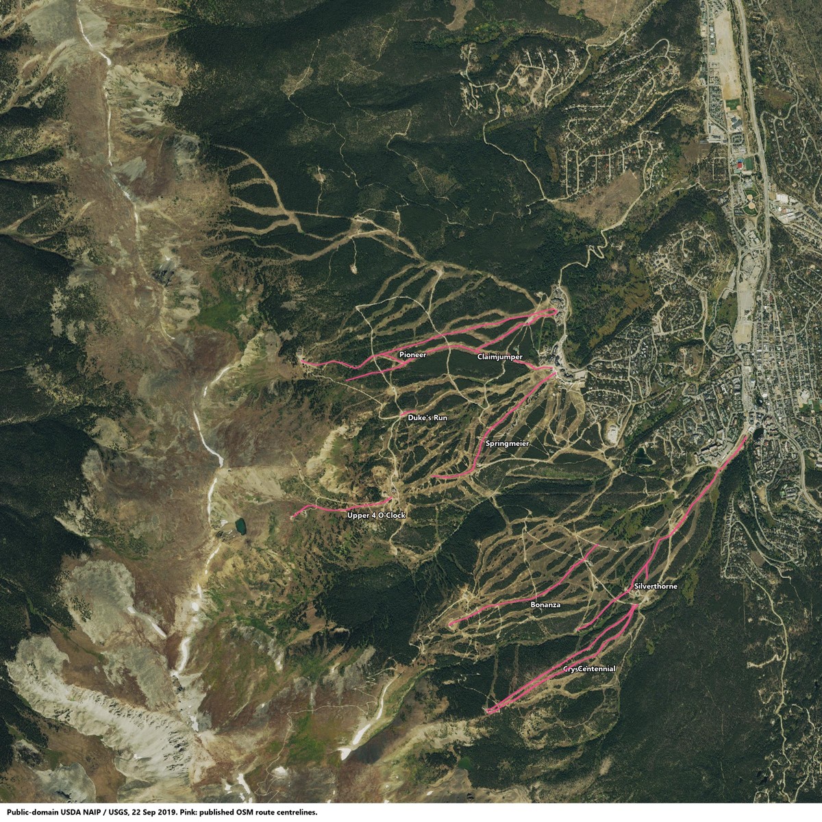 Imagery: USGS / USDA NAIP, public domain. Route overlay: OpenStreetMap contributors, ODbL 1.0. Download route database.
Elevation differences
The model gives FIVE SuperChair a ground rise of 215.6 m. The current official map lists 302 m; an older official map lists its predecessor at 217 m. The 2025 image follows the mapped corridor. This suggests a published-statistic inconsistency, rather than evidence to move the lift, but it does not independently prove the correct current engineering rise.
Independence differs by 23.2 m and Rocky Mountain by 10.3 m. Their sampled terminal locations fit the aerial reference. Ground elevations, cable/loading positions and published figures may differ; the exact cause remains unresolved. No coordinates or elevations were forced to match the brochure.
Show all 21 lift-rise comparisons
| Lift | Official map | Model ground rise | Difference |
|---|---|---|---|
| BreckConnect Gondola | 121 m | 116.5 m | -4.5 m |
| Colorado SuperChair | 404 m | 400.7 m | -3.3 m |
| QuickSilver SuperChair | 193 m | 192.7 m | -0.3 m |
| Falcon SuperChair | 428 m | 427.1 m | -0.9 m |
| Independence SuperChair | 402 m | 425.2 m | +23.2 m |
| Kensho SuperChair | 468 m | 468.6 m | +0.6 m |
| Freedom Superchair | 316 m | 313.2 m | -2.8 m |
| Zendo Chair | 97 m | 96.2 m | -0.8 m |
| Peak 8 SuperConnect | 434 m | 432.9 m | -1.1 m |
| Beaver Run SuperChair | 485 m | 484.9 m | -0.1 m |
| Mercury SuperChair | 447 m | 446.8 m | -0.2 m |
| Rocky Mountain SuperChair | 380 m | 369.7 m | -10.3 m |
| Imperial SuperChair | 286 m | 285.9 m | -0.1 m |
| Rip's Ride | 93 m | 92.7 m | -0.3 m |
| FIVE SuperChair | 302 m | 215.6 m | -86.4 m |
| A-Chair | 189 m | 187.4 m | -1.6 m |
| C-Chair | 382 m | 383.1 m | +1.1 m |
| E-Chair | 296 m | 293.5 m | -2.5 m |
| 6-Chair | 302 m | 301.1 m | -0.9 m |
| Snowflake | 192 m | 191.4 m | -0.6 m |
| Horseshoe Bowl T-Bar | 376 m | 373.0 m | -3.0 m |
Terrain and remaining limits
Published route endpoints round-trip through the model’s coordinate transform within 0.007 m, excluding source accuracy. The 30 m display mesh differs from the more detailed route elevation samples by a median 0.32 m, 1.83 m at the 95th percentile and up to 9.04 m locally. These are internal rendering checks, not independent elevation validation.
Learning-carpet and platter-lift positions remain unverified. The check does not certify every route, current lift operation, piste boundaries, trail difficulty, decorative widths, trees, building heights or snow conditions. The map remains a geographic preview.
References and evidence
- USGS / USDA NAIP service and public-domain description
- Current official resort map
- 2021 official map, predecessor 5-Chair rise
- Resort’s lift replacement history
- Recent imagery: Esri World Imagery / Vantor, 27 July 2025, declared resolution 0.34 m and accuracy 8.47 m. Inspected as a reference only; no imagery or newly traced coordinates are included in the 3D map.
- Download review measurements and scope